In the Summer of 2009 me and my mate decided to raise some monies for Cancer research by organising a sponsored walk across Morecambe bay. I had read a book about Cedric Robinson the Queen's guide to the sands but he sounded a bit strict so I decided to let Alan Sledmore have a go.
The Dates when walks are being done can be found on the web.
The walk we did starts from Hest Bank and ended at Kents bank a walk of about nine miles..
Here we are looking all nice and clean and raring to go and raise some cash. In total there were about 200 people doing the walk and our group of 40 set off in a ramshackle sort of way following Alan and his helpers.
It soon became clear that the only suitable foot ware was bare feet.
Alan and his helpers use a variety of motors to get across and they will take you on a trip out into the bay to see the cockle beds.
If anyone gets tired or has sore feet Alan will let you ride his tractor..
The sands are very firm and easy to walk on and we never saw any sign of quick sands..This is us about halfway across..
I was surprised at how quickly you lose sight of land and if you attempted this walk on your own you would need a strong constitution and a tide table.
Of course crossing the bay wouldn't be fun without getting a bit wet and you have to cross one or two little rivers
If your not up to wading you can always jump on a tractor to get you across..Some people had dogs with them so I guess you may have to carry it across here..
As you can see everybody made it safely across. This is us as we approached Kent's bank in Grange over Sands.
All in all this was a great way to spend a Sunday Afternoon and in total we raised 2000 pounds for a good cause..
The walk today goes up Wild Boar fell twixt the Yorkshire dales and the Howgills. This walk is mostly on open access land where dogs are not allowed to go. I ignore this sort of stuff and always take lassie.
On a clear sunny day the scenery is as good as anywhere and on a frosty day the ground is hard otherwise it would be a real bog fest.
Navigating is the name of the game up here and here are my mates doing some.
The Settle to Carlisle railway runs down through the valley and crosses the Smardale viaduct.
We took a good few stops to admire the view and try and find the path.
Anybody who is better than me with a camera could get some cracking shots..I think I may need a UV filter to get a clearer picture.
The fells round here are enormous.See how this farm is dwarfed by the surrounding hills.
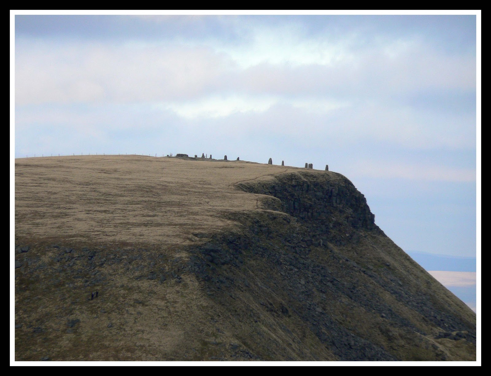
On top of the Nab there are a series of cairns.If you know the origin of these then do tell.From a distance we thought there was a bunch of people up there.
All in all this is a long and tiring walk of about 12 miles and the going is a bit tough underfoot. As the daylight started to fade I put on my head torch and we came across some animal neglect.
This Shetland pony was frozen solid next to an empty plastic container. Under normal circumstances I would have gone to the farm and told them about their pony but it was off the route and didn't look very welcoming..
When my Niece her husband and me decided to go up Scafell Pike I was just glad of the opportunity and when he decided to do it barefoot I wasn't concerned..They were camping up the lakes so we arranged to meet at the Old Dungeon Ghyll pub..When they turned up riding a tandem I knew I was in for something less ordinary than one of my usual walks.
I was all prepared with my usual walking boots and rucksack with every conceivable thing you could need when Tom announced he was going to try it barefooted and Kirsty said she would be ok in her wellys! I persuaded Kirsty to at least try my wife's boots on and when they fit her I felt more comfortable myself.
Tom does have rather large feet.
I know how quickly things can turn to S**t on these hills but I had studied the MWIS weather forecast and they predicted a short break in the recent bad weather so off we went..
As we crossed the foot bridge over Rosset Gill there were a group of guys repairing the worn away footpath. Tom got some second glances as he strode confidently from rock to rock on his size 12's'.
Further on we came across a small patch of Sundew plants.Tom being a keen environmentalist had a smile from ear to ear when he saw these, I tried to photograph them but it came out wonky.
When we got to Angle tarn I wasn't in the least surprised when Tom decided to go for a swim.
From here on up the ground becomes very rocky but it did nothing to slow Tom's progress and soon we were at the top.
Tom wanted to go one higher so he promptly climbed the trip point to the amazement of the other walkers.
Tom comes from a family with lots of walking experience. His father has walked the entire length of the English coast. When ever he came to an estuary he simply swam across. He started this mammoth undertaking in his teens and finished when he was in his mid fifties..
Coming down from Scafell Pike Kirsty offered me a piece of Marmite flavored chocolate..It is the most disgusting thing I have ever tasted and I spent the next few miles trying to spit it out..
When we got back down to Angle tarn we decided that as the weather was nice we would do Bowfell as well.
Here they are on top of Bowfell, the air was so clear we could see the Isle of Man in the distance. On the way back down the Band we passed this lovely cottage.
When we got back we had a pint in the Old Dungeon Ghyll. This place doesn't seem to have changed in the forty years I known it and I bet it could tell a few tales from the things that have happened here over the years.
So we managed our walk and Tom's feet seemed no worse for it..After we said our goodbyes Tom and kirsty got on their tandem and rode off back to their tent ..
This walk starts from the village of Dunsop bridge where you can park
your car next to the 100000th BT payphone that was opened by Sir
Ranulph Fiennes himself.. The plan was to try and find the Whitendale
and Brennand hanging stones which are supposed to be the centre of the
British Isle, The route leaves the village and follows the small brook
upstream and onto the moors.
The
weather was quite cold but the sky was blue enough and you very quickly
leave civilisation behind as you follow the water board service road.
The hills round here are mostly boggy peat and are the sponge that feeds the surrounding reservoirs.
The views up here in the forest of Bowland are like no other you are likely to see and the area seems to be seldom visited.
I had a map and ignoring the no dogs signs I quickly came across an obvious pointer to my destination.
The
weather turned typically misty and following a bearing became tricky as
the ground underfoot throws you first one way and then the other..I
also had to negotiate big peaty scars where the streams had eroded away
the topsoil..These detours can wreck your intended path so try and keep
an eye on some thing in the distance so you can regain your bearing.
Out
of the mist appeared some stones which fitted the bill I was looking
for so I had a butty and admired the mist for a while..Whether these are
the Brennand or Whitendale stones I know not.
From
here I decided to make for the trig point on Whins Brow,its about two
miles I guess but the walking is bloody hard work.You have to cross
small valleys with steep sides where you have to grab lungs full of air
and the surrounding heather to drag yourself up,
The
ground is real hard work and when I saw a fence heading the right way I
made a bee line for it and used it as a handrail all the way to the
top.
On
the way up I saw a farmer bouncing and rocking his way across the moor
on his quad bike, it looked very uncomfortable indeed. By the time I
reached the trig point I was huffing and puffing like a good un'
The
tarn is Brennand tarn where I found a geocache and sat and admired the
views into the empty distance..I once read that the Queen comes up here
shooting and as she owns most of the land she can do as she pleases I
guess..
From here I grabbed another handrail fence and stumbled slipped and slithered my way back to Dunsop bridge for a brew.
This walk starts from the Marton Arms Hotel at Far Westhouse just
outside Ingleton.There is plenty of parking at the stocks by St Oswalds
church.
Follow
the road uphill for about 1 mile until you reach a sheep pen on the
right with a path heading into the open fields. This path is a cheeky
way of getting a free view of Thornton force waterfall.
Follow
the Waterfall path up to the ice cream van and then climb the steep
path up onto Twistleton scar.There are some peculiar limestone rocks up
here..This is my mate from down south.
The
path now crosses the limestone pavement for a mile or so and you can
stop off and have a look down some of the potholes or sinks.
The path now crosses a small ford and turns right towards Chapel le Dale.
As you approach Chapel le Dale there are two very interesting things to see..Firstly is a statue by Charles
I'Anson which was uprooted and thrown down Hurtle pot.
The statue was recovered from hurtle pot by divers..This is me going down to the entrance of Hurtle pot.
The church of St Leonards is close by and you can stop for some lunch.
Once
while we were having our lunch I got talking to Will Alsop the guy who
designed 3 chips in Manchester and Peckham library, he was amazed that
we were going to walk up Inglebrough..
This is our intended route that amazed him....The next bit of the walk is hard work and often misty.
When you get to the top of the Devils staircase you can have your photo took like we did.
From here it is a short walk to the trig point and 4 sided shelter and then the path wends its way down towards Ingleton.